2026-04-28 Western Behm Canal Trip
- Michael Youngblood
- 1 day ago
- 10 min read

I had really been wanting to make a trip up to Klu Bay in Western Behm Canal because it is such a beautiful place to visit. But it's about 50 miles to get up there so it is a long run for my slow boat. Because of that I usually try to make a 3-day 2-night trip out of it. That was the original plan for this trip however plans changed significantly mid-trip.
Here is a map snippet from my Garmin InReach that shows my track for this trip. I did make it to Klu Bay for a day and a night but ended up spending more time in Marguerite Bay than originally planned.

Ketchikan is way down at the bottom and Klu Bay is up at the very top. You can see where I cut into Traitors Cove & Marguerite Bay a little more than half-way up.
I had a bit of tense few minutes when I went to fire up my engines for this trip. The starboard engine would not even try to turn over. I made a panicked call to my mechanic and with his help eventually determined that there was a breaker on one of my electrical panels that had popped for some unknown reason. Once I reset that everything worked fine and I was able to start my engines without any problems.
I had my cat Luna with me for this trip. She does pretty well on the boat. Cats are weird. I have a carrier that I use when I transport her from home to the boat. As soon as I put her in it, she starts complaining very loudly, all the way down in the truck. When we get to the boat I let her out and I leave the carrier sitting there with the cover open. And then she climbs in and spends a lot of time just hanging out in there. I just don't get it!

As soon as I start the engines, which is a very noisy process, she runs and hides. I don't see her again until I shut down the engines.
I really wanted to have a fire in my fire pit on this trip, and I can't do that if I am on the anchor or on a mooring buoy so I decided to poke my nose into Marguerite Bay and see if I could get up to the dock. When I got there, I saw that there was a large vessel named the Poseidon tied to the side float and a big barge tied to the side near the big rock.
On almost all of these USFS floats the front of the dock is designated and marked as loading and unloading only, no long-term mooring. But this dock was rebuilt just last summer, and they have not yet marked the front in that manner. So, I guess I could have tied up on the front face of the dock, but instead I decided to tie up to the mooring buoy that is very near the dock. When I have my dog Nova with me it is much more convenient to be at the dock so that I can walk her easily, but since I had Luna, it wasn't that important to be tied to the dock. When it came time to have a fire in the evening, I could just take everything into the dock in the raft.
Here is Faraway on the mooring buoy in Marguerite Bay.


The mooring buoy is about 200 yards or so from the dock.
Here's a shot of the Poseidon. It is owned by Amak Towing in Ketchikan. The USFS is in the process of rebuilding the bear & fish viewing platform that is about a mile up the logging road, and some of the workers on that project are living on the Poseidon. They have a little ATV that they use to run up and down the road to the project site.

We saw one guy that was living on it many times and chatted with him from time to time. It looked like he had his young son living with him on board as well.
That's my raft tied alongside the dock. There's a story associated with that as well.
The small motor, or "kicker" that I use for the raft is a Torqeedo, which is electric. I like it because it breaks down into 3 components with the heaviest of those being only about 10 lbs. My old 4 HP Suzuki outboard weighed 65 lbs.
In any case when I mounted the Torqeedo on the raft and tried to fire it up it acted as if the battery was at 0% charge. My practice is to always charge it all the way up to 100% right after I use it so that it is ready for the next adventure. I shrugged it off and just rowed into the dock. But later as I investigated further, I determined that the problem was the connection between the battery and the rest of the motor. I finally gooped up the connection with dielectric grease and that seems to have solved the problem. It's always something on a boat!
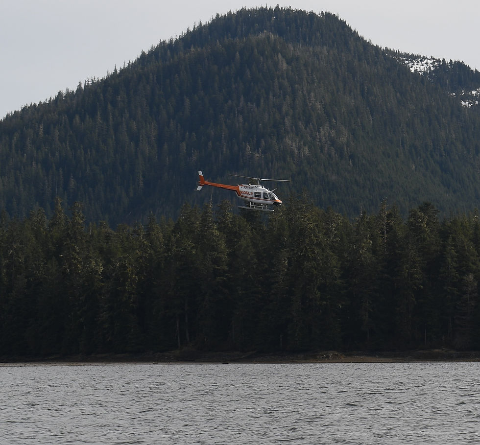
There must have been a VIP working on the project to rebuild the bear & fish viewing platform because a helicopter came in each morning and left each evening. I never did find out who that VIP was.

While I was on the mooring buoy, I noticed this pair of Mergansers swimming back and forth repeatedly. I assume that's the male in front with the smaller female following behind. They went back & forth numerous times on seemingly the same path in front of those rocks.

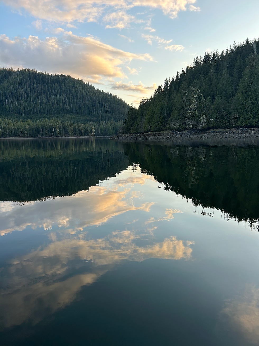
Here are a few scenic shots of the area. These days I am using my iPhone for about 50% of my photos and my "real camera" Nikon for the rest.


So, this is where the plot thickens. I am not a spontaneous person - I am a planner, on an almost obsessive scale. I try to plan my trips down to the last detail, and once I have a plan in place I very rarely deviate from it. My plan for this trip was to spend Tuesday night in Marguerite Bay and have a fire on the dock. Then on Wednesday run up to Klu Bay and stay the night there on the mooring buoy. And then run all the way home on Thursday. But ...
I have had Starlink Wifi for almost 2 years now and it has been a game changer. When I got it, I did not realize that I would also get WiFi calling and my cell phone would be active.
I got a call from one of my boating buddies. He starts out with "Are you in town?" I said no, I'm up at Marguerite Bay. He asked if I wanted to join up with him and one other guy and do some shrimping and crabbing. Shrimping has been closed for March and April and was due to reopen on Friday May 1st.
I said sure, where are you planning to go? He said, "Where you are, at Marguerite Bay."
So my plan for the trip changed. They were planning to come out in 2 boats on Thursday afternoon. I decided to stay where I was for Tuesday night and then run up to Klu Bay for Wednesday and Wednesday night, and then run back down to Marguerite Bay on Thursday to meet up with my buddies for some shrimping and crabbing.
Woo-hoo, a new plan!
On Wednesday morning I pulled away from the mooring buoy and headed up Western Behm Canal to Klu Bay. Up at the "corner" where you make a hard starboard turn at Brow Point there was evidence of a fairly large landslide. I don't recall seeing it last year when I was up in this area so it must have been fairly recent.

Here's a map snippet that shows the route up from Marguerite Bay and Brow Point which I called the "corner" because you make a hard starboard turn there. Brow Point is marked with a blue 'X.' You can see Klu Bay over to the right.

Here's a more detailed map snippet of Shrimp Bay and Klu Bay. You must pass through Shrimp Bay to connect into Klu Bay. The small blue X's mark the 2 waterfalls that are at the end of Shrimp Bay. I cricled the mooring buoy in blue. It looks like it is on shore in this map but it's actually in about 50' of water.

Here are some scenic still shots and some video from my short time in Klu Bay. No one else came in while I was here, which is just how I like it.


You can see that we had a bit of rain while I was there.


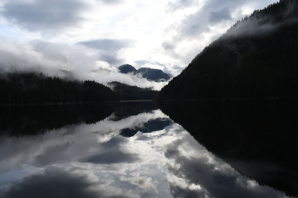


Klu Bay, a truly beautiful place to hang out for awhile.
I had set my 2 crab pots in the afternoon and on Thursday morning I pulled them. One of the pots was completely empty but the other one had 3 crabs in it. They have to be 6 1/2" across and males in order to keep them. These 3 were all males, but they were about 1/8" shy of 6 1/2". If I had been heading home that day I might have kept them anyway, but I knew we would be catching more crabs when my buddies arrived so I tossed these 3 back.
On my way out of Klu Bay on Thursday morning I stopped briefly in front of the 2 waterfalls at the back of Shrimp Bay and got some short videos of them. They are side by side and they are pretty impressive.
After viewing the waterfalls in Shrimp Bay I made my way back south to Traitors Cove and Marguerite Bay again to await the afternoon arrival of my buddies.
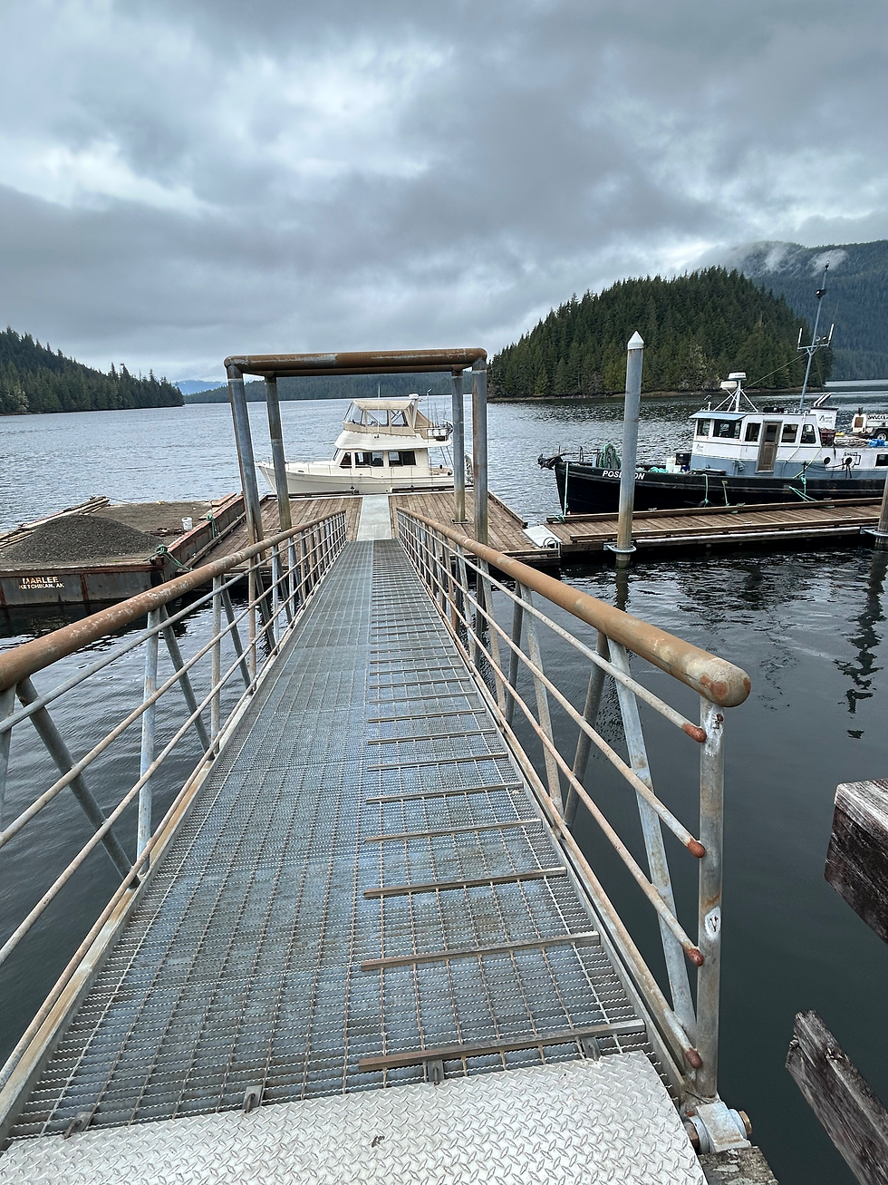
When I got back to the dock nothing had changed, it was just the Poseidon and the barge there. Since the front, or face, of the dock was not marked for loading & unloading only I decided to tie up there.
Here's a shot taken before the crowds arrived.
My buddies arrived in early afternoon right on schedule. They both have fast boats, so it only takes them about an hour to get out here while it takes me over 3 hours.
They do crabbing & shrimping on a different scale than I do. I carry 2 crab pots and 2 shrimp pots with me at all times, and I drop them whenever weather, location and timing allow. They came with 20 shrimp pots and about 15 crab pots, along with copious amounts of bait and other supplies. They do things in a big way!
Shrimping was still closed on Thursday so that afternoon we focused on crabs.
There is a "salt chuck" around the corner from the dock that leads to a sort of lagoon. The entrance to that back area is very dangerous and can only be crossed at certain stages of the tide and with local knowledge. Here is a map snippet that shows where the salt chuck is in relation to the dock.

On this map the blue X marks the location of the USFS dock and the blue circle marks the rapids that guard the entrance to that back area. Of course, the best crabbing is in that back area, but most people can't get back there. Maybe that's why the crabbing is so good back there.
One of my buddies grew up in this area and has been running that entrance since he was a kid. He has a jet boat which means it is very fast and it does not have any propellers. It uses a water jet for propulsion.
Here are a couple of drone videos that show the jet boat shooting those rapids at high speed. There is no audio for the drone videos.
My buddy is becoming a pretty good drone pilot!
We dropped a bunch of crab pots back there for later pickup after they had had time to soak a bit.
We spent the rest of the evening preparing the shrimp pots so that they would be ready to set in the morning when the season opened.
Some other boats started coming into the dock in the afternoon.

That metal boat on the right side is a USFS boat. They came out to check up on the progress of the work being done on the bear & fish viewing platform.

One guy came in and tied to the side of the barge. You can't tell from this photo because the tide is pretty high but there is a huge rock on that side just a few yards from the side of the barge. But there was just enough room for him to moor his boat there.
Later we went back into the area where the crab pots were and pulled them. Here's a drone video that shows the process of pulling a pot. The boat has an electric pot puller with a foot switch that activates it. That's me pulling the pot, with one of my buddies driving the boat and the other flying the drone.
We got a pretty good haul of crabs from back in that area.

In the morning we went out and set all 20 of the shrimp pots. They were set in Traitors Cove "proper," most of them within sight of the USFS dock.
These are set considerably deeper than crab pots. Crab pots would usually be set at 100' or less, while shrimp pots could be set anywhere from 300' to 600'. That's why it is essential to have a pot puller when pulling shrimp pots. Pulling them by hand is possible but it is very difficult. The other difference is that there is only 1 crab pot on each line while on shrimp pots there might be 3 or 4 pots on the same line.
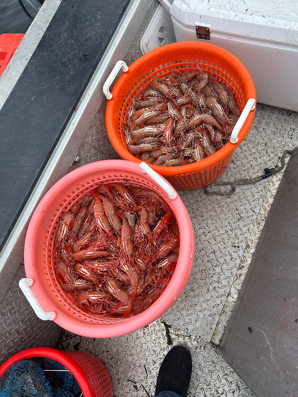
Later when we went back out to pull the shrimp pots, we did pretty well.
All the crabs were cooked right there on the dock. They use a big propane cooker for that with a huge cook pot.
The protocol for the shrimp is to "pop" off the heads and put the tails in quart zip lock bags. They are not usually cooked right away on the dock unless someone wants to eat some right away.
We had a nice evening on the dock visiting with some of the people from the other boats. The weather was nice and it was a good time.
On Sunday morning we had a couple more shrimp pots to pull and then we started to make preparations for departure.
I pulled out well before my buddies did, but with their fast boats I'm sure they made it back before I did.
I got back to town around noon after logging about 95 miles for this trip.


Comments