2025-10-25 Carroll Inlet Trip
- Michael Youngblood
- Oct 27, 2025
- 7 min read

I was really undecided about even making this trip. The weather on Saturday was a bit iffy, while Sunday looked pretty good. But then I realized that our City League basketball season is about to start and once it starts, I am very limited in when I am able to get out for overnight trips. So that pushed it over the top, and I decided the trip was a go.
Some may recall that about a year ago I left in the dark and hit something in the water that caused a lot of expensive damage to the boat. Since that time, I have done two things to mitigate that risk. First, I have installed a light on the bow pulpit that is supposed to light up the water in front of the boat so that I can see the logs. More on that a little later. And second, I have not been running in the dark since that incident.


It was difficult and expensive to get the light mounted on the bow pulpit. Running 12 VDC power up there was a real challenge. And the light itself was not inexpensive. So, it is doubly frustrating that it does not work; it is useless. In its present configuration it cannot be pointed downward at an angle so that it illuminates the water. At present it gives me a very nice view of the bow pulpit railing. I'm working on a solution.
I am officially now in "winter mode" as it is late October. What that means is that I have to do things a bit differently. Here are some things that I do differently in winter.
I take all my salmon trolling gear off the boat. I leave some bottom fishing gear on board because if I find myself in a promising location and the weather is cooperative then I will drop a line down and try to get a halibut.
I put on board a small step ladder and a big push broom with an extension added to the handle. When it snows I will get out on the flybridge extension, get up on that step ladder, and use the push broom to push all the snow off the flybridge cover. I don't want it to sag under the weight of the snow. It's a miserable job, but it needs to be done.
I pilot from the lower helm rather than from the flybridge helm. My boat was built in Georgia, so it is basically a warm weather boat. The flybridge helm is the standard helm and the lower helm was an option that I added when I bought the boat new in July 2007. Here is what the lower helm looks like.

You can see that I have two GPS devices, the larger one on the right side and the smaller one on the left side. When I pilot from the flybridge helm I move the larger unit up there. The smaller device does not support radar or AIS, but it has GPS charting, depth, routes, etc.
The small Furuno unit in the middle is the controller for the auto pilot. There is an identical device on the flybridge helm.
Visibility from the lower helm is not as good, but in the winter the flybridge is all iced up as there is no heat up there. So, I have no choice but to navigate from the lower helm station in winter.
Back to the trip...
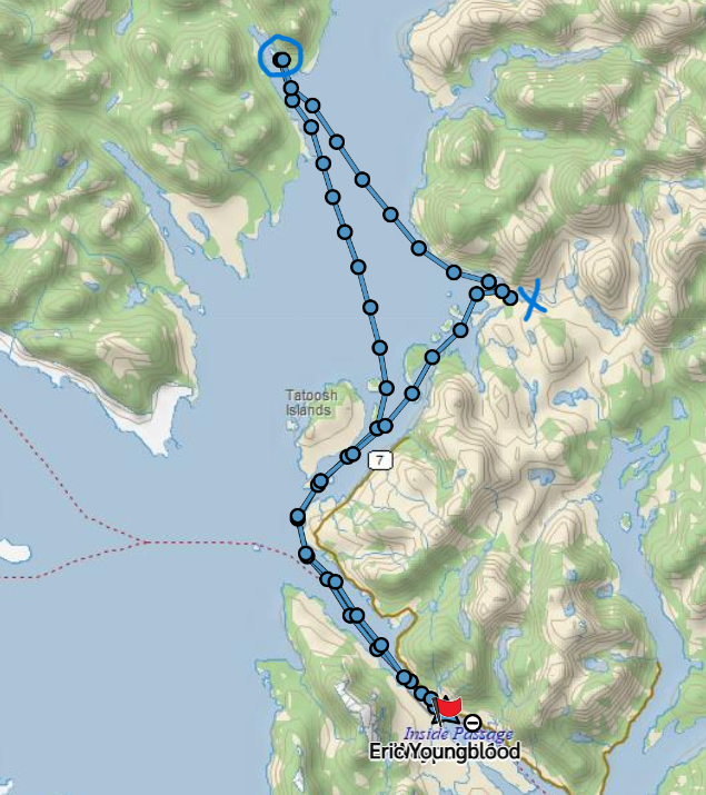
Here is a map snippet from my Garmin InReach that shows my track on the way out there.

The point marked as "A" is where I dropped my 2 shrimp pots. The point marked as "B" is the little cove where I spent the night.
Here is a more detailed map snippet of the little unnamed cove just North of Osten Island where there is a mooring buoy.

Several years ago, the Ketchikan Yacht Club took on a project to get that mooring buoy placed in this little cove. I imagine there was a flood of paperwork, permissions & permits that had to be dealt with before they could actually get the work done.
That is not where I had hoped/planned to spend the night. I wanted to spend the night at what we call the Shoal Cove USFS dock, which is right across from where I dropped the shrimp pots. I say we call it the Shoal Cove dock because as strange as it may seem, it is not actually in Shoal Cove. Shoal Cove itself is way too shallow for a boat like mine to enter. Only small skiffs can go in there.
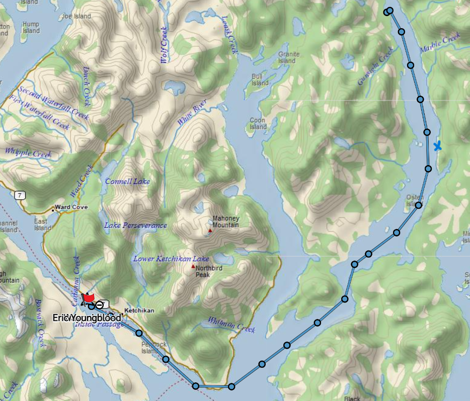
Here is another map snippet that shows the layout of things in this area a little more plainly.

The "X" mark at the top is the point farthest North where I dropped my shrimp pots. The arrow pointing to the right is where the Shoal Cove dock is, where I had hoped to spend the night. The "21" with a circle around is the little cove with the mooring buoy in it where I ended up spending the night. You can also see Shoal Cove itself a little bit South of where the docks are. The green color indicates that it is very shallow in there.
There are actually 2 docks at the location that we call the Shoal Cove dock. The USFS has a dock there, and the USCG had a dock there as well. I say "had" because the USCG no longer uses or maintains the smaller dock across from the USFS dock.
The USCG used to maintain a LORAN site that was a way up the logging road that is accessible from these docks. LORAN was the primary navigational system used before the advent of GPS. The LORAN station has been dismantled and is no longer in use. But, for a long time the USCG ferried men and equipment out to this area to work at that site.
Here are some shots of the USFS dock on the left, and the old smaller USCG dock on the right. It is hunting season now and I suspect that all or most of these boats were there to go hunting up on the logging roads.


After dropping my shrimp pots, I made my way back South to that little cove and made fast to the mooring buoy. It's a nice little cove and by this time the rain had stopped, and the weather was actually getting nicer. The water was dead calm inside the little cove.
I don't have any shots of the boat on the mooring buoy because I was too lazy to launch the raft to go out and get photos.
It's a beautiful area though and I did get some scenic shots during my brief stay here.


The snow is starting to creep down the mountains, and it will be down at water level soon.

At this time of year, it gets dark pretty early. There was a very nice sunset right before dark. This was a pretty nice place to hang out for a while and spend a quiet night on the mooring buoy.

I just hung out on the boat for the afternoon and evening. I never get bored. Now that I have WiFi on board I can work on my iPad and on my laptop. I have a TV as well and I could watch movies or sports, but I rarely do that anymore.
I thought about launching the raft and setting my crab pots in the cove, but I have done that before here and have never been successful, so I did not do that. I did drop a "crab snare" down. This is a small bait basket surrounded by large loops of monofilament. The idea is that the crab will come in to investigate the bait and get tangled up in the loops. You just drop it down on a fishing rod. I have gotten crabs in this manner in the past, but I got none on this trip.

Somehow something was getting the bait out of the basket. I would pull it up and check it from time to time and most often I had to add bait. I don't know what kind of critter down there was getting the bait without getting tangled in the loops.
Commercial crabbing season is open and there were a few crabbers in the area. I had to be especially vigilant when running the boat because there were literally hundreds of pots in the water around this area.
On Sunday morning I pulled my two shrimp pots to disappointing results. There were only 2 shrimp in each pot.
These are my shrimp pots. I have a larger one that I took off for the Glacier Bay trip, and I have not put it back on board yet.


I liberated the 4 shrimp as it is too much work to cook only 4 shrimp.
Here is my Scotty pot puller. It is pretty simple and works very well. It is just a vertically mounted capstan that turns, and you put a couple wraps of the line around it and it pulls the pots up. It is 12 VDC, so it is not all that powerful, but it works well for my needs. And it is easily stored away when not in use.
On the way back to town, right in front of the USCG base, there was a small USCG patrol boat roaming around. A smaller, faster boat passed me, and they immediately pulled him over and boarded him. I don't know for sure, but I suspect that they got him for speeding in Tongass Narrows. There is a 7-knot speed limit in this area, but smaller boats are exempt. I suspect he thought he was exempt because of his size but was actually not exempt. I don't really know what the exact length cutoff is for the exemption, something like 24 or 25 feet, I think.

I cruised slowly past them at 6.5 knots and when they finished with him, they went right into the USCG base and did not bother me at all.
I got into the slip without any issues as the weather was very calm.
I logged about 49 nm for this trip.
I was pretty disappointed in the shrimping, but I will try again the next chance that I get.

Comments